Skip to content
Click here for smartphone site
Chichibu Geopark
Sanctuary of Geo Learning that
Fosters Protectors of the Earth
日本語
English
Access
Contact
HOME
What is a Geopark?
Search geosite
Geostory
Recommended route
Notice
Events
Yoshida/Ogano/Ryokami Area
HOME
Search geosite
Yoshida/Ogano/Ryokami Area
List of " Yoshida/Ogano/Ryokami Area"
Geosite 25
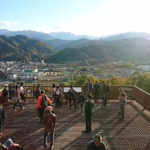
White Sandstone Layer of Shirasuna Park
This is a park developed on top of a bedrock of white sandstone, which is a coarse sandstone made of rock deposits from the early period of the formation of Paleo Chichibu Bay. The view from the top of the rocky mountain is superb.
You can enjoy approximately 5,000 Katakuri (Dogtooth violet) flowers that have been planted in the park while taking a stroll through the promenade every year between late March and mid-April.
Geosite 26
Large Outcrop of Torikata
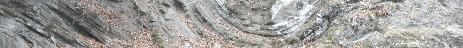
You can see the stratum from the time when Paleo Chichibu Bay, which existed about 17 million to 15 million years ago, was still a deep sea. A dynamic stratum is exposed over a width of approximately 800m, showing proof to the present that this location was submerged in the deep sea in the past. It is designated as a national natural monument.
You can observe a twisted stratum that was formed through landslides at the bottom of the sea (folds), a time difference between strata (discordance), and a stratum created over a long period of time on the sea bed through sand and mud (turbidite) that has a distinct striped pattern.
Geosite 27
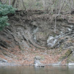
Sea Floor Landslide Remains of Toroku
When this area was still submerged in the sea, a slope was formed on the sea bed due to the bulging of mountains, and the sediments on the sea bed that had not solidified yet slid down due to earthquakes, resulting in a curved strata (slump fold) that can be observed here.
Geosite 28
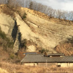
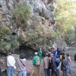
Yobake
You can see the stratum when Paleo Chichibu Bay, which existed about 17 million to 15 million years ago, was still a shallow sea. Many fossils have been excavated in this location giving testament to the fact that this was a rich habitat of marine creatures back when it was part of the sea. Yobake is a large outcrop that is representative of Chichibu, and it has been designated as a national natural monument and selected for the Geology 100 Selection of Japan.
“Yo” of Yobake refers to “Taiyo” or sun, and “bake” refers to “gake” or cliff in Chichibu. Yobake thus has the meaning of “cliff shone under the sun,” and this is how local people called it since the past.
Geosite 29
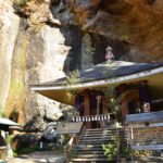
Ofuneiwa and Tafoni of Hosho-ji Temple (Chichibu Pilgrimage Temple No. 32)
On the back of the temple dedicated to Kannon, there is a mysterious cave with many holes in it like a bee nest. This is caused by a weathering phenomenon called Tafoni, in which the salts in the rock seep into the surface, crystallize, and then break the surface of the rock.
Ofuneiwa (literally means “boat rock” in Japanese) is a large sandstone on a precipitous cliff that is protruding like the bow of a boat. At the tip of this rock is enshrined Ofune Kannon (“boat Kannon”). This is an excellent sightseeing spot where you can overlook the entire Chichibu Basin.
Geosite 30
Kannon-in Temple (Chichibu Pilgrimage Temple No. 31) and Iwadono Sawaishi
The large rock cliff around the temple dedicated to Kannon is a sandstone deposited on the sea bed around 17 million years ago when the Chichibu Basin caved in and the ocean began to cover the region. On the rock face next to Seijo Falls, which has a height of 30m falling from the rock cliff, there is a small Buddha figure carved on a rock surface.
At the temple gate is a monolithic Stone Nio Guardian that is the largest of its kind in Japan. This statue and other stone Buddhas and stone walls are made from the so-called “Iwadono Sawaishi” or local tuffaceous sandstone. This is a stone material that has been used in various locations of the Chichibu region from long ago.
Geosite 31
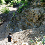
Inuki Discordance
You can observe a discordance where the stratum from the ocean from around 100 million years ago during the age of dinosaurs, and the stratum created in the sea bed when Paleo Chichibu Bay came into existence during the age of mammals, come into contact after a period of roughly 100 million years. The discordance is designated as a national natural monument.
Geosite 32
Conglomerate of Minamotozawa
The valley where Minamotozawa is located in a region with an extended stratum that was deposited approximately 130 million to 100 million years in the past during the age of dinosaurs. Kenji Miyazawa, who is a prominent Japanese poet and a writer of children’s literature, visited this place during his geological excursion in Chichibu in 1916.
Geosite 33
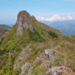
Limestone Rock Cliff of Mount Futago
This is a rocky mountain made of limestone on the Chichibu belt with two steep summits. Just like Chichibu’s landmark “Mount Buko,” it was born from the South Sea far away and moved on top of an oceanic plate that pushed it against the continent. Fossils have been found here such as of fusulina and sea lily.
It is famous as a full-scale rock climbing location that is easy to access from the Tokyo metropolitan area, and many hikers visit during the hiking season.
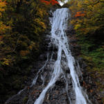
Geosite 34
Marugami Falls
This is a stunning waterfall that falls from the mountain stream flowing from Mount Ryokami, which is a mountain that looks like a saw that towers on the west side of Chichibu Basin and is made of a large chert rock body. It is the only waterfall in Saitama Prefecture selected for Japan’s Top 100 Waterfalls.
Culture/History Site
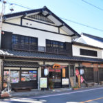
Former Kotobuki Ryokan (Ogano Town Tourism & Interaction Hall)
The hall uses the building that had originally been built as the government office of a magistrate in 1716, and it had been turned into a long-established ryokan (inn) where many travelers from long ago had stopped by known as the Honjin Kotobuki Ryokan. Currently, it is renovated into a tourist base facility of Ogano Town.
Kenji Miyazawa, who had been at Morioka High School of Agriculture and Forestry, stayed at this ryokan when touring the Chichibu region to inspect its geological features back in 1916. Materials related to Kenji Miyazawa are put on display, and visitors can learn about his tracks back from that time.
Culture/History Site
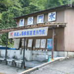
Bishamonsui
This is one of the 100 Exquisite and Well-Conserved Waters of the Heisei Period gushing out from the mountainside of Mount Hakuseki in the inner depths of Chichibu. The water has a rich calcium content.
Bishomon Kori, a signature shaved ice of the region using Bishamonsui, is a Geogourmet delicacy that you would definitely want to try out when visiting Ogano.
Ecology Site
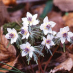
Natural Habitat of Setsubunso at Dojo
This is one of the largest natural habitats of setsubunso (Eranthis pinnatifida) in Japan. Setsubunso blossoms around late February to mid-March, and the delicate white flowers that are about 2cm in diameter look like a blanket of snow. They are jun-zetsumetsu kigu shu (near endangered), but preservation activities are being carried out locally.
Viewing Spot
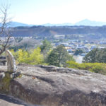
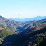
Shiki-no-Michi Ogano Observatory
This is an observatory on the Shiki-no-Michi (four seasons road) walking path located on the border of Ogano Town and Chichibu City. Visitors can enjoy a sweeping view of Mount Ryokami and mountains in west Chichibu.
You can also look out over the landscape of Ogano, which has developed as a strategic point on the roadway leading to Nagano from old times, and also observe a wave-like landform called Cuesta.
Viewing Spot
Shigasaka Toge
This is a mountain pass from Ogano Town in Chichibu District to Kanna Town in Tano District, Gunma Prefecture. This was a roadway from long ago that connected Saitama to Gunma and Nagano.
Visitors can observe the ou-chitai (concave area) with a stretch of stratum from approximately 130 million to 100 million years ago (Cretaceous Period of the Mesozoic Era) in the age of the dinosaurs.
Base Facility
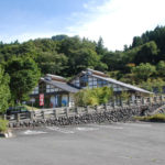
Kurao Furusato Kan
Main Facility
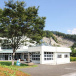
Fossil Museum of Ogano
Return to top of content
Return to top of page
Return to top of content
Return to top of page